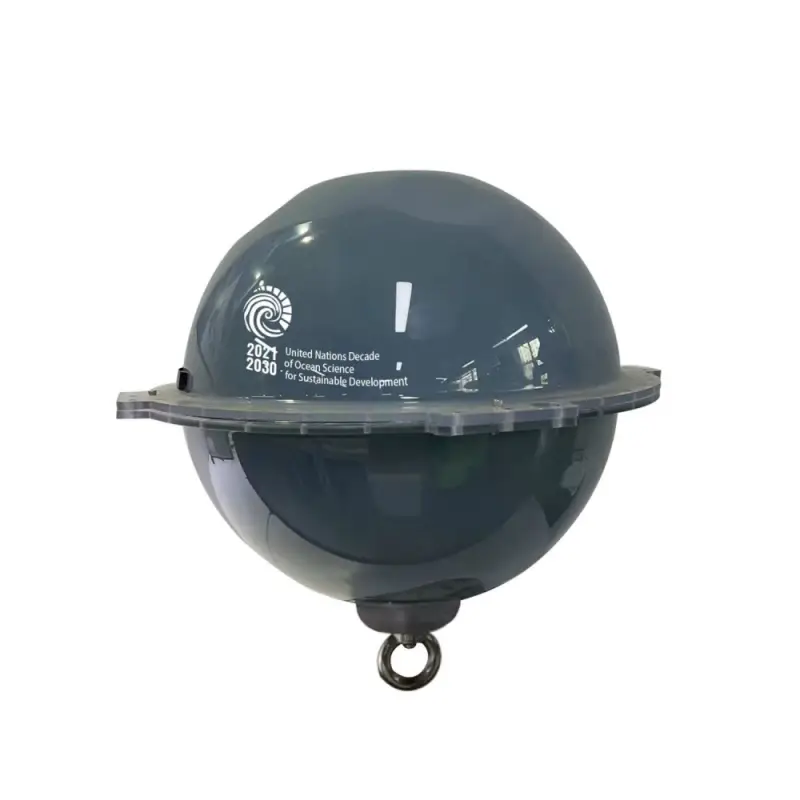
Through its Ocean Decade Programme “Ocean to Climate Seamless Forecasting System (OSF)”, the First Institute of Oceanography (FIO) of China’s Ministry of Natural Resources has created new-generation Global Navigation Satellite System (GNSS) surface drifting buoy. Being extremely low-cost, high-precision and intelligent, the developed GNSS surface drifting buoy provides significant opportunities for improved ocean observation and monitoring.
The new-generation GNSS surface drifting buoy created by Professor Fangli Qiao, Principal Investigator of the OSF Programme and Deputy Director General of FIO, and his team, uses free signals from GNSS satellites to accurately obtain 10 important variables: geographic position, time, surface wave height, period and direction, surface current velocity and direction, surface sea temperature, surface sea salinity, and atmospheric water vapor content.
This achievement draws on years of seminal research led by Prof. Qiao, also a member of the Ocean Decade Advisory Board, who demonstrated how small-scale ocean waves play a crucial role in large-scale ocean circulation and the climate system, through modulating upper ocean mixing and air-sea fluxes. For this reason, ocean surface wave observation is of vital significance in itself, also in large-scale ocean circulation and global climate change.
Throughout history, there have been three major revolutions in global ocean observation. In 1978, the first ocean color satellite made large-scale synchronous ocean observation possible for the first time. In the 1980s, the development of tropical buoy arrays started, and the global tropical large-scale fixed-point continuous observation network was established, which has greatly improved the monitoring and prediction capabilities of El Niño-Southern Oscillation. At the beginning of the 21st century, a global ocean observation initiative – Array for Real-time Geostrophic Oceanography (Argo) – was launched. Today, about 4,000 Argo buoys are in operation in the global oceans, observing a vertical profile approximately every 10 days, and making real-time monitoring of the ocean in three dimensions a reality. The Argo Programme is also part of the Global Ocean Observing System (GOOS), co-led by UNESCO’s Intergovernmental Oceanographic Commission. High cost remains the bottleneck and great challenge of ocean observation, although tremendous efforts and series of technical achievements have been made.
Since 2016, through in-depth marine multidisciplinary cooperation and by using GNSS satellites including the BeiDou, Prof. Qiao’s team has made technical breakthroughs in buoy hardware design and data processing. These include low-cost GNSS single-station, real-time high-precision online velocity and position determination, real-time online inversion of multiple elements including wave elements and water vapor content, wide-spectrum expansion and capture of wave spectrum, multi-element coding transmission and control integrated with BeiDou satellite Short Message Communication (SMC), optimization of low-power and high-performance algorithms, miniaturization of buoys and wave-following optimization, and more. Such progresses have vastly improved the inversion accuracy, avoided the cost of precision differential correction services, and dramatically reduced the communication burden.
The results of several field observation experiments and comparisons demonstrate how the precision of this groundbreaking new buoy is on a par with other commonly used wave-measuring instruments such as the Waverider, indicating only centimeter-level difference. Observation costs have also been dramatically cut: the cost of the GNSS buoy is 90% lower. In other words, the observational cost of the new GNSS buoy is under 10% of the present system.
This financial aspect is particularly relevant, as it has hindered the deployment of a comprehensive ocean observing system. Despite notable progress over the last 45 years, ocean observations still face challenges of high costs and sparse coverage, which directly hinders the scientific understanding of ocean processes and the ability to predict the ocean and climate. Indeed, the upper ocean and lower atmosphere are not only closely related to human activities at sea, but also key to understanding climate change.
Based on their initial findings, Prof. Qiao and his team are developing four types of GNSS buoys. Type-A GNSS buoys are the basic configuration, which can obtain the above 10 variables, simultaneously. Type-B GNSS buoys are capable of capturing five more atmospheric variables, i.e., wind speed and direction, temperature, humidity and air pressure. By deploying a large number of Type-B GNSS buoys, real-time observation of the global large-scale air-sea fluxes will become a reality, and the contribution of surface waves will be considered exactly in the calculation of air-sea fluxes. Type-C GNSS buoys can measure seawater temperature and salinity structure from 0 to 300 meters, in addition to the conventional 10 variables, as well as accurately capture ocean internal waves, thanks to artificial intelligence control software. Meanwhile, Type-D GNSS buoys, besides the conventional 10, can measure underwater noise, which can be used to monitor marine mammals and protect marine ecology.
The new GNSS buoy developed by FIO is intelligent, which means it can automatically perform intensive observations at any time according to needs, such as large wave areas, internal waves, ocean hazards and more. In the future, through further technological breakthroughs, it will also aim to detect eddies, and measure precisely global tidal levels, further safeguarding vulnerable coastal communities around the world.
***
Read the full article:
Liu et al. 2022. Real-time precise measurements of ocean surface waves using GNSS variometric approach. International Journal of Applied Earth Observations and Geoinformation, 115, 103125. https://doi.org/10.1016/j.jag.2022.103125
For further information, please contact:
Dr. Li Li, Director of the International Cooperation Department; Senior Scientist, First Institute of Oceanography, Ministry of Natural Resources
li.li@fio.org.cn